Chasing Brown Bears...Our Journey to the Edge of Alaska and the Inside Passage
- khdeutmeyer
- Oct 5, 2025
- 13 min read

“There are journeys that etch themselves into memory, not merely for the sights but for the sense of awe they inspire."
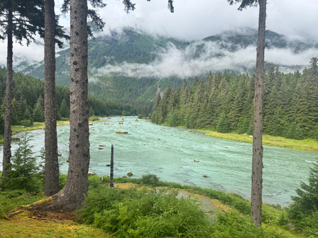
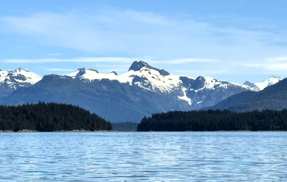
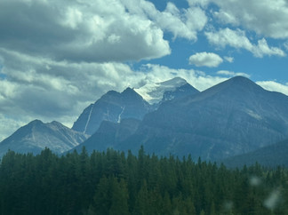
In my quest to find brown and grizzly bears tucked away at the southernmost tip of Alaska, we flew into Calgary, Alberta, Canada. We rented a small SUV in Calgary and started our journey to Hyder, Alaska. The route from Calgary to Hyder took us through the Canadian Rockies traveling on the Icefields Parkway. The drive took about three hours without stops, features numerous viewpoints, glaciers, hiking opportunities, and cultural and natural attractions, and if lucky enough, wildlife along the roadway. We drove this route from Banff National Park to Jasper National Park on two other trips to Canada, and each time I was in awe at the beauty and viewed it as if it were my first time traveling through the Parkway. This route is considered one of the most beautiful drives in the world. Services along the route are limited, so it’s wise to fill your tank, pack snacks, and bring layers—the weather can change suddenly and dramatically. Cell coverage is sporadic and restrooms are few and far between. Below are photos from our drive through the Canadian Rockies and the Icefields Parkway.


The Icefields Parkway drive from Banff to Jasper
It took us two days of solid driving, approximately 20 hours to travel from Calgary to Hyder. We stopped overnight in Prince George, British Columbia to break up the drive before reaching Hyder. This area of Alaska is surrounded by mist-covered mountains and dense temperate rainforest. Hyder is geographically isolated from the rest of the United States by rugged wilderness. The only road connecting Hyder to the outside world is the Cassiar Highway, a route that winds through lush landscapes, past glacial rivers and through the heart of the beautiful Pacific Northwest.
Hyder is often called "the friendliest ghost town in Alaska.” With a year-round population around 60, Hyder is the only Alaskan town accessible by road from British Columbia, Canada. The town sits at the head of the Portland Canal, a narrow fjord carved deep into the coastal mountains.

To reach Hyder, we drove the Cassiar Highway, officially known as British Columbia Highway 37. The Cassier slices through the heart of the wilderness country. Unlike the more heavily traveled Alaska Highway, the Cassiar is less developed. https://themilepost.com/routes/cassiar-highway/
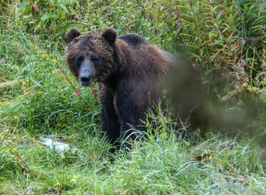
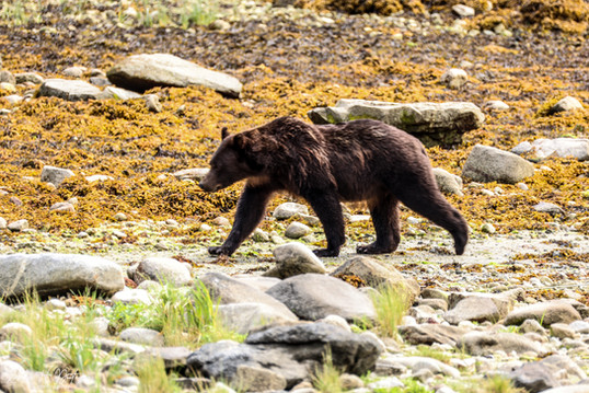
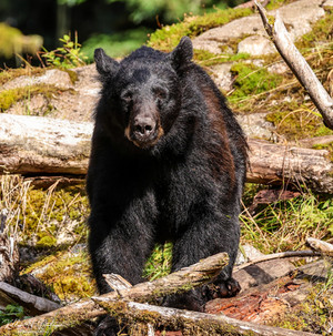
Services are sparse, gas stations can be more than a hundred miles apart, and cell phone reception is intermittent at best. We made sure our vehicle was fueled up and we had food in the car to eat along the way since services were few and very far between. We were fortunate to see a beautiful grizzly bear grazing on the roadside flowers. We also saw hundreds of logging trucks filled with tree logs headed for the Portland Canal and as the locals explained to us, the logs are dumped onto a ship for China.


The last major stop before Hyder is Stewart, British Columbia, a charming town nestled at the end of the Portland Canal. Stewart and Hyder are separated only by a thin, invisible line. We crossed the Canadian/U.S. border from Stewart to Hyder several times a day headed to the Hyder Fish Creek Wildlife Observation in my quest to find brown bears fishing for salmon. With Hyder being a ghost town, there are no hotels or restaurants in the community so we stayed in Stewart at a local Airbnb. It was nothing fancy but served its purpose for a few nights. Stewart has a grocery store and a few restaurants but food was very expensive!
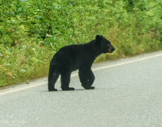
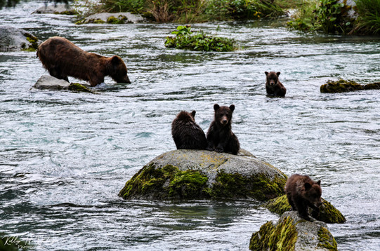
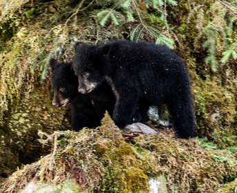
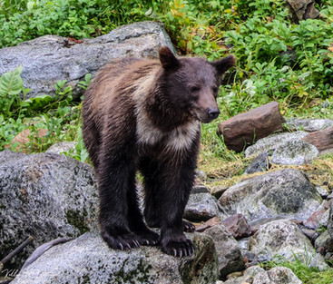
My mission to reach Hyder was to visit the Fish Creek Wildlife Observation area. https://www.adfg.alaska.gov/index.cfm?adfg=bearviewing.fishcreek. In the summer months, the Fish Creek Wildlife Observation Site is a magnet for wildlife enthusiasts. I had read that brown bears and black bears gather to feast on spawning salmon offering close-encounters with these bears. Unfortunately, we spent two full days in Hyder at the Fish Creek Wildlife area and saw thousands of salmon in the creek but only saw one brown bear fishing. The bear stayed at the creek for two hours so we were able to see him eating many fish, but it was disappointing that this was the only brown bear we saw. We also saw one black bear crossing the road in front of our car, but it didn’t find its way to the creek. Eagles are plentiful in Hyder. We saw many eagles on the way to the observation area in the creek bed.


Fish Creek Observation Area, Hyder, Alaska
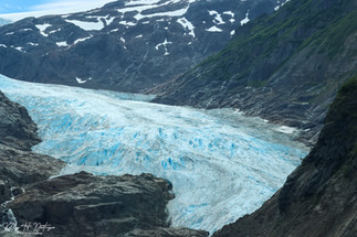
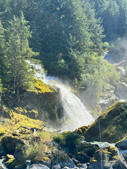
Just outside Hyder is the Salmon Glacier. We took a 15 mile drive up a mountain on a gravel road past the Fish Creek Observation area. Once at the top, the panoramic views are amazing, and the views of the glacier are unbelievable. This was a highlight of our trip to Hyder. https://stewart-tourism.com/what-to-see-do/signature-experiences/salmon-glacier


Salmon Glacier and the surrounding mountains outside Hyder, Alaska
Exploring the Gems of Southeast Alaska: Wrangell, Stika, and Haines
Among the treasures along the Alaska Inside Passage are three towns each offering their own unique amenities: Wrangell, Sitka, and Haines. Since this was a trip dedicated to viewing brown bears, we traveled to each location in search of bears!
HAINES: THE ADVENTURE GATEWAY BETWEEN MOUNTAINS AND FJORDS
Haines is at the top of our favorite places in Alaska outside of Katmai National Park Brooks Falls! Haines is a very small community of approximately 2,000 residents with a dramatic backdrop of snow-capped mountain peaks, glacier-fed rivers, and the Chilkat Inlet. This time visiting Haines, we arrived by ferry from Skagway. Our drive from Hyder, Alaska routed us to Skagway and then onto the ferry to Haines. The Alaska Marine Highway is a very efficient system and an incredible way to travel the inside passage. https://dot.alaska.gov/amhs/index.shtml


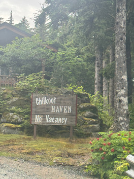
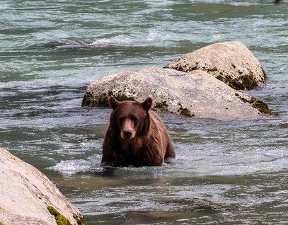
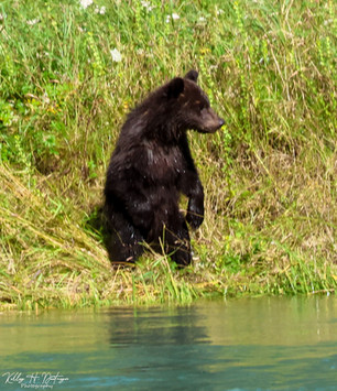
Haines has limited hotel accommodations and restaurants but our favorite place to stay is the Chilkoot Haven overlooking the Chilkoot River Five miles outside of Haines. https://dot.alaska.gov/amhs/index.shtmlabout We noticed on this visit that camping seemed to be the popular way to visit Haines. We were definitely in the minority traveling without a camper! We find Haines the most incredible location to relax and enjoy the amazing views and the brown bears fishing for salmon. It is by far the best place to view brown bears without taking an expensive float plane or boat trip to a remote Alaska location. Below are views of the Chilkoot River and Chilkat mountain range.


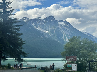


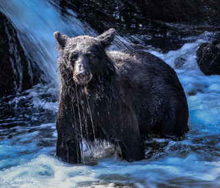
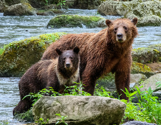
The brown bears in Haines wander the Chilkoot recreation area among the fisherman in the water fishing for salmon. In the months of June to the end of August, a fishing weir spans the Chilkoot River. The State of Alaska Fish and Wildlife conduct a salmon count annually during this timeframe. The staff conducting the count on the weir can hinder the bears and their ability to use the weir to catch salmon, but when the staff finish a shift, the bears tend to find their way to the weir to do their salmon fishing! We tend to time our trips into town around the Fish and Wildlife staff hours on the weir counting salmon, or we take a drive searching for eagles at the Chilkat Bald Eagle Preserve hoping to see more brown bears along the way. The most important point to remember, bear watching takes time and patience!
Don’t expect to dine at fancy restaurants in Haines. The options are limited! There are a couple of local bars, a pizza place, an Asian/American restaurant and an IGA grocery store if you want to do your own cooking. Shopping is limited too with a few souvenir stores and that is it! Haines is about the views of the snow-capped mountains, peace and tranquility, the eagles and the brown bears!


WRANGELL: GATEWAY TO THE ANAN CREEK OBSERVATORY HOME AND THE TONGASS NATIONAL FOREST
South of Haines, nestled on Wrangell Island in the Tongass National Forest, you’ll find the charming yet rugged town of Wrangell. Wrangell is less traveled than other communities located in the inside passage but definitely worth the trip!
We departed Haines on the Alaska Marine Highway ferry and cruised to Juneau. This is an absolutely gorgeous trip through the longest and deepest fjord in North America, Lynn Canal surrounded by snow capped mountains and hanging glaciers. From Juneau, we flew to Wrangell on Alaska Air. The Alaska Marine Highway doesn’t operate a regular ferry service to Wrangell so flying was our only option. Wrangell is a small community of 2,200 people, with two grocery stores, one hotel, very few restaurants. But the Sitkine Inn and Restaurant has one of the best places to eat in town! We ate there three of four nights we were in town! https://www.stikineinn.com/ With limited hotel options we stayed at an Airbnb and rented a car through Turo. Other than visiting Anan Wildlife Observatory and the LeConte Glacier, Wrangell doesn't have many tourist attractions. There is a small museum and a city park. Views of Wrangell are below.


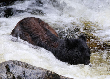
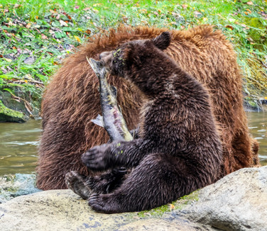
Wrangell is known as the “Gateway to the Stikine River.” The Stikine River is the largest mainland river that bisects the Coast Mountains that link Southeast Alaska to the interior of Canada. It is an incredibly important resource for the birds, wildlife, fish, and people of the area. Our reason for traveling to Wrangell was to take an excursion to Anan Wildlife Observatory. During July and August, you can watch black and brown bears fishing for salmon in close proximity. The trip to Anan didn’t disappoint!
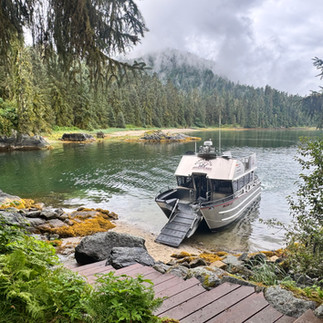
We reserved two Anan tours with different tour providers, Muddy Waters Adventures and Alaska Charters & Adventures. We had different experiences on both days, but Alaska Charters & Adventures was a full day tour and the tour we enjoyed the most. From Wrangell, it is a one hour boat ride to Anan or a 30 minute float plane ride. We opted for the boat ride. We were dropped off at the beach and walked 1/2 mile to the viewing platform. Only 60 permits are issued for visitors to Anan keeping the crowds at a minimum.


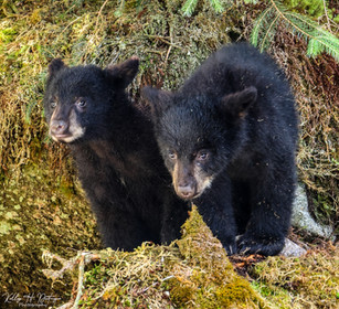
With Alaska Charters & Adventures, https://alaskaupclose.com/ we arrived at Anan Observatory earlier than other boats and had time on the viewing platform with the bears before other people arrived. We were fortunate to see many black bears including females with their cubs and a couple of single brown bears fishing for salmon. Anan has two viewing platforms with bear viewing in all directions from the platforms. There are times when you are not sure where to look with bears everywhere! The lighting can be very tricky for photographers, and the bears can get very close, so I used two cameras and my cell phone! During the peak salmon run season, Anan Observatory has a live cam feed. Bears and the river can bee seen at the following link. https://explore.org/livecams/three-bears/anan-forest-view Below are the incredible bears, eagles, and views of the Anan Wildlife Observatory.


We booked a LeConte Glacier tour with Muddy Water Adventures. The LeConte Glacier https://en.wikipedia.org/wiki/LeConte_Glacier tour took us through the Dry Straits (part of the Stikine River Delta) to LeConte Bay, where we encountered hundreds of icebergs from golf ball size to Titanic size! We navigated through the seven-mile fjord through towering snow-capped mountains to the face of the glacier. We have seen many glaciers over the years, but this one was unique. Approaching the glacier there were pieces of ice floating in the water that had broken off the glacier and seals laying on these floating ice pieces. When visiting Wrangell, this is a must do trip! Photos are below of the LeConte tour


Wrangell is a special community and if visiting the inside passage, I wouldn’t miss it!
SITKA: WHERE RUSSIAN HERITAGE MEETS ALASKA WILD
We departed Wrangell and flew to Ketchikan then to Juneau and our third leg finally took us to Sitka. We could not find a direct flight between Wrangell and Sitka and the Alaska Marine Highway does not have regular service to the island. Unfortunately, weather was not cooperative while in Sitka. It rained for three days straight. One of our main attractions to Sitka was the Mount Edgecumbe volcano, located 15 miles away from Sitka. We wanted to see the volcano but unfortunately with the rain and the fog, it was hidden behind the clouds!
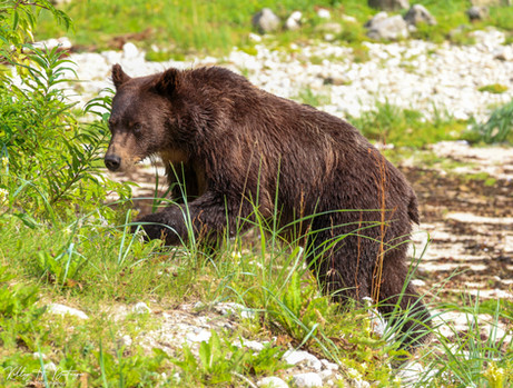
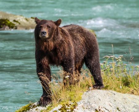
Sitka’s population is approximately 8,400 residents. The island has several lodging options, restaurants, and shopping. Sitka was the first capital city of Alaska when it was transferred from Russia back in the mid 1800's. There is a significant Russian history and influence throughout the island. Our main reason to visit Sitka was to find brown bears but bear viewing was limited. I was disappointed. When doing my research for the trip, I talked to a tour operator that sold me on a day trip to Hidden Falls to view brown bears in their natural habitat.
Hidden Falls was a three- hour boat ride from Sitka, six hours round trip! If I had known it was a three-hour trip one-way, we would not have gone! Hidden Falls is a fish hatchery and not a typical location for brown bear viewing. The positive of the trip....the brown bears are abundant at Hidden Falls and we were the only tourists there! The bears wandered out of the wooded areas from all directions to fish on the weir and in the water near the weir for salmon. In a couple of instances, the bears snuck up on us as they were headed to the weir to fish and got a little too close for my comfort level! We were able to see several different female brown bears with cubs and a few solo bears. The bears were exciting to watch but it wasn’t worth the expensive cost of the trip or the long boat ride to get there. The brown bears of HIdden Falls are pictured below.


In addition to the Hidden Falls trip, and in our pursuit of trying to see brown bears on the Island of Sitka, we regularly visited Starrigavan Recreation Area. Starrigavan has campsites, cabins, and trails and the local residents told us we could see brown bears early morning or late afternoon. Unfortunately, we didn’t see one bear at Starrigavan after making several trips a day out to the recreational area. The salmon were running but the bears were not!
Overall, Sitka probably is a lovely community and a great place to visit, but for our purpose of seeing brown bears in the wild, it is not the best option. I don’t foresee us returning.
THE ALASKA HIGHWAY: GATEWAY TO THE LAST FRONTIER
After our adventures in Haines, Sitka, and Wrangell, we flew from Sitka to Juneau, hopped on the Alaska Marine Highway Ferry to Haines and started our journey back to Calgary. We couldn’t drive from Juneau because it is not accessible by road from the outside; it is one of only two U.S. state capitals not connected to a road network. You can only arrive by boat or plane. While there are roads within the city, they do not connect to any other communities or the North American road system. Taking the ferry to Haines, we could connect to the Alaska Highway taking us back to Calgary. The Alaska Highway traverses a vast wilderness in a remote area of North America. The highway has been completely paved but there are limited services so it is important to keep the gas tank full and have a dependable vehicle. We were fortunate to see a couple of moose along the highway and several black bears as we made our way from the Alaska Highway to the Icefields Parkway and back to Calgary for our flight back home. Below are photos of the gorgeous views while traveling the Alaska Highway and the Icefields Parkway on our drive back to Calgary.


Whether you travel by ferry on the Alaska Marine Highway, cruise ship, or small plane, the journey to Haines, Wrangell, and Sitka is as breathtaking as the destinations themselves. Each town is unique and offers its own comfortable lodges, cozy B&Bs, and welcoming people eager to share their community. Plan for rain (bring a good jacket and hiking boots), prepare to disconnect from the bustle of city life, and be ready to be surprised by both the vastness of the wilderness and the warmth of these communities.
I have been asked several times if we would drive to Alaska again. It was a bucket list trip we talked about for years. Something we dreamed about doing in retirement. But would we do it again, no. It was an adventure I would never give back but there is so much to see in both Alaska and Canada, that each deserves its own vacation.
TIPS TO TRAVEL ECONOMICALLY AND GET THE MOST FOR YOUR TIME AND MONEY
I also get asked many times, "How do you travel so often and keep it affordable?" A few tips are below:
For me, planning and researching is part of the excitement of the trip! Visioning is so much fun!!!
I plan all of my own trips and research, research, research on the internet. I utilize TripAdvisor, Frommer's, and blogs from other travelers to find the information I need for my trip. I do a massive amount of reading and researching. It takes patience to plan a good affordable trip!
I have a budget in mind for each trip and challenge myself to stay in the budget. Depending on the location, I typically start planning and booking hotels, cars, etc., approximately 9 months out. Hotel prices usually get more expensive the closer to the trip unless you are willing to do a last minute internet deal. Car rental and airline prices also go up the closer it is to your trip. Occasionally you can get a last minute deal but something else may be more expensive and you are really not saving. I like to plan!
For hotels, I use Airbnb, Hotels.com, Booking.com, or Priceline.com. I look for hotels with good reviews, pay when you stay, and free cancellation in advance.
If we are flying, I use the Skyscanner app to check airfare prices and I try not to buy until about 60 to 75 days out. There are times where I will by earlier if the price is super reasonable. I usually do not book on Skyscanner. It will tell me the site that is the most affordable to purchase the tickets and if it is a more well known trust site, I go directly to the site to purchase the tickets. Many times Skyscanner will take you right to the airline website. Skyscanner will search all airlines and will sort by price, times, shortest trip, etc.
Have a credit card that gives you miles or hotel points. We will use points for many of our trips. We are American Advantage members and have an Advantage credit card. We try to fly American as often as we can to earn points and then use those points for future airline tickets. Our credit card is tied to our Advantage numbers and awards points as well.
We drive if the location is in the United States and we can drive and sightsee along the way. If we need to rent a car, we reserve online using Booking.com, Orbitz.com, or Priceline.com. This trip we tried out Turo. it worked well! They are usually the most reasonable. I watch for specials and never book a luxury vehicle! We also have a credit card with a low limit that we use for vehicle rentals that provides insurance as a credit card benefit. We always decline the insurance when we are in the United States. If we are traveling out of the United States, we check with the credit card if the insurance is valid internationally. We have found it is valid in Europe, Canada, U.S. Virgin Islands, but in other locations, we are forced to purchase the liability insurance from the rental car company.
While there are free maps online for most destinations, I always go onto Amazon and buy a map of my destination, especially if it is international. I do not buy maps for tropical Caribbean islands. I just get one when we arrive. But for countries like Canada, Costa Rica, Panama, Belize, England, Canada, Germany, France, etc., I always purchase a good map. As you do you research, you can use the map to highlight the places you want to visit and the sites you want to see. I have it as a reference later for putting my memories and photos into a photobook!


Comments